As the modern age of hunting progresses with the continued use of technology, many hunters are turning to online mapping applications to increase their hunting success. Hunters planning out-of-state excursions rely heavily on digital mapping applications and online viewing. Geographic Information Systems (GIS) maps are loaded with landowner information and allow you to find every finite detail you may want to know about a property or region. Google Earth can allow you to zoom to street or highway level and see the landscape as if you were driving backroads. Whether remotely planning a hunt hours away, or piecing together buck patterns on your local property out the back porch—online mapping is playing an ever increasing role in successful hunts. Here’s a look at how to do much of your deer scouting with Google Earth.
How It Works
Hours of time can be spent behind a computer etching plans for future hunts. Finding the right application for your needs is important. If you are scouting land for an out-of-state hunt, few mapping tools can rival free access to Google Earth for getting to know the general area you may be going. Topography, water sources, and general terrain features can all be viewed from the palm of your hand in a free application. The desktop version of Google Earth can even show you how the sun moves about terrain and the landscape. How is this useful? Well, plan a food plot and you will need sunlight in the area you are planting. Using this sunlight tool can also help you plan locations for trail cameras and help you avoid facing cameras at glaring sun when you expect deer to walk by. Find out where the sunlight hits most during winter and you could find yourself a shed hunting paradise.
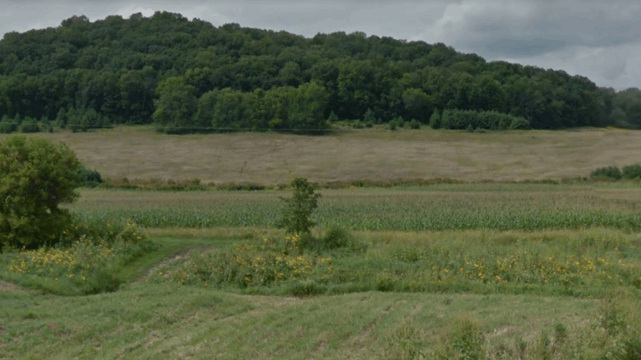
This Google Earth Street View actually allows you to see trails across the CRP field (top center).
After gaining a general understanding of a region you are hunting, pinning down specific land information by using public GIS mapping tools might be necessary. Private landowner names, land borders, measuring tools, and even soil and tax information can all be found using GIS data. Each county has publicly accessible GIS tools. If you are brave and determined, you could even reach out to private landowners asking them for advice or perhaps hunting permission. It might seem like this is an extreme measure to do this legwork, but after all, it is public information. Once on the move or in the field, onX Hunt, HuntStand and others also offer GIS mapping capabilities as well as the ability to save and mark locations such as tree stands, cameras, rubs, scrapes and anything you can imagine right from your phone. Many of these applications have basic free access with in-app purchases available.
Benefits
While nothing beats ‘boots on the ground’ scouting, deer scouting with Google Earth, or other mapping app is hard to beat when you are looking for general clues of where to begin your hunt. I often find myself staring at a Google Earth view of properties I hunt, attempting to find terrain features which may explain deer movement. If your property has a land feature which may funnel deer a certain way, look for similar terrain on your neighbor’s land and you may be able to figure out how they may move from their land to yours.
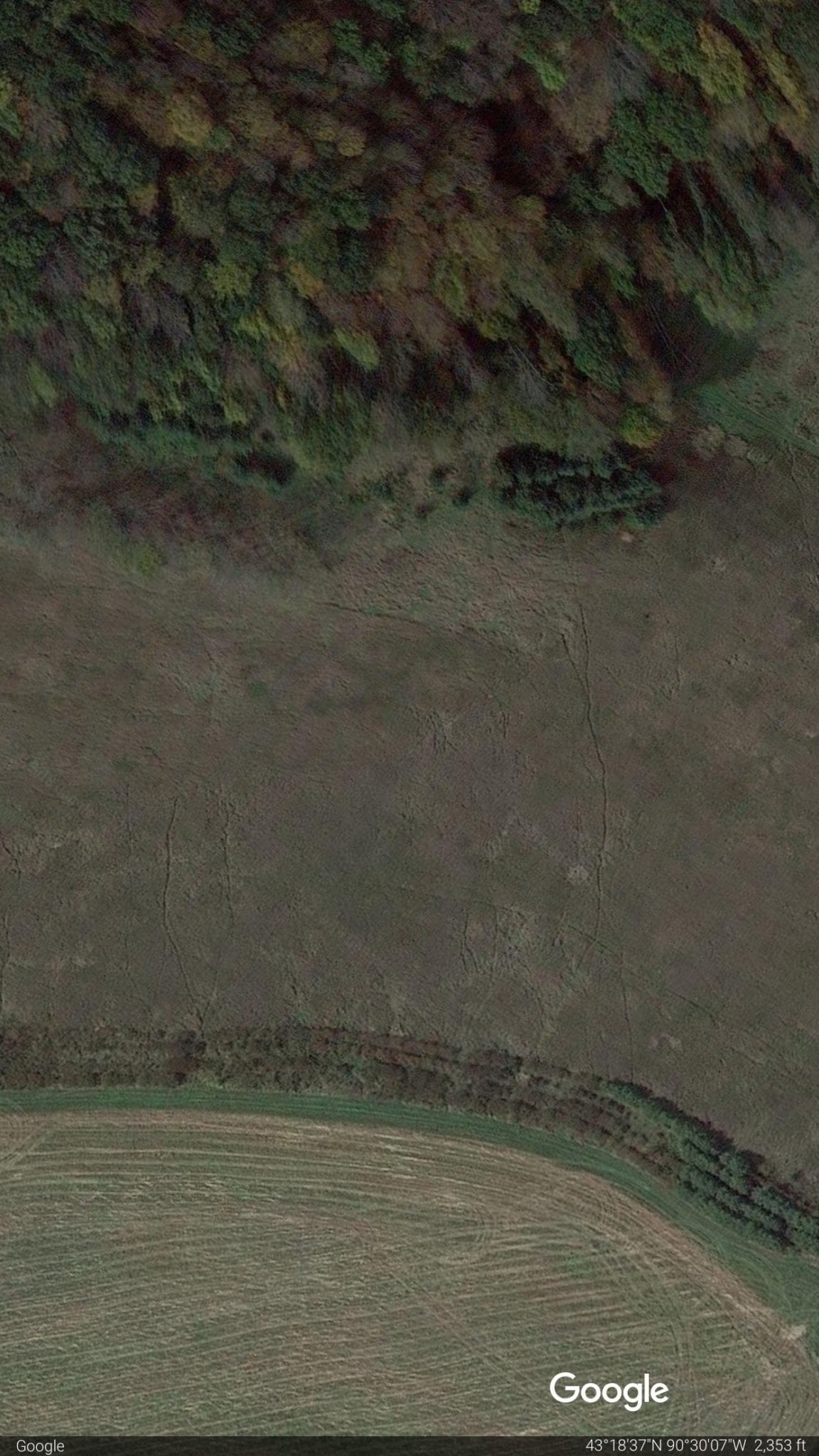
The Google Earth “Earth View” option gives us an aerial view of the same trails in the CRP field from the photo above.
Deer scouting with Google Earth will allow you to see trails through grassy areas such as CRP fields and pasture-like sections of land. Backtrack trails from open areas into the timber and from there you can predict how a deer may travel from bedding areas to fields by way of land terrain.
Depending on your hunting location, Google Earth Street View can be a dynamite way of digitally scouting. If roads near a public land access point are on Street View (smaller county roads are sometimes not on Street View) you can determine if certain access points seem too accessible and could possibly cause high hunting pressure on a portion of the property. If all roads surrounding a public land parcel are on Street View, you can virtually drive around the property and scout entry and exit strategies and have a high level Google Earth view to match up potential stand sites. While scouting via street view you can even tell what species of trees may dominate the area. If the photos were taken during fall, you can easily view Oak trees as they hold their leaves longer, and from there find a hot acorn tree once you are at the property.
Downsides to Deer Scouting With Google Earth
Potential downsides to online scouting occur when it is relied upon as the only source of your scouting regimen. Using digital mapping tools are obviously a great way to scout new areas without being in-person. However, avoiding ‘boots on the ground’ scouting and solely relying on mapping could be a huge mistake. The last thing you want to happen is to show up for a prime-time rut hunt and realize the property did not lay out the way you envisioned. Viewing satellite photos taken years prior and only trusting that information could be a mistake. It could be as simple as a recent logging that took place, or a few downed trees completely changing an area’s ability to be bowhunted. Diversify your scouting techniques by using trail cameras, speaking with neighbors, and then use online mapping to help confirm or solidify your calculated assumptions.
Deer Scouting With Google Earth – Wrapped Up
Online mapping can be a critical part of planning a hunt and expounding on your scouting efforts. Using online mapping applications in addition to in person scouting and trail camera usage is the ultimate way to successfully prepare for the upcoming season. Advancing technology is only going to increase the way we utilize digital maps to aid in our hunting success in the days ahead.