LAST UPDATED: May 8th, 2015
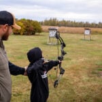
Through my years of hunting I was always looking for a secret to consistently harvesting a trophy every fall. I have learned through time that one tactic to consistently filling your tag every year is by scouting and wearing some rubber off of your shoes. It’s not easy, and it takes time, but it works.
We’ve all scouted in one way or the other, and we’ve scouted both public and private property. What I’m going to cover in this article, is how to take all the information that you gain throughout the year and how to compile it into an easy to understand portfolio, so that when you step back and look at the particular property that you are hunting, potential stand locations with a high percentage of success will literally jump out at you. The items that you use to scout your property can be as high tech or as simple as you choose. What I will explain is not the only way to scout, but hopefully gives you some new ideas that you can use where you hunt. I will discuss the use of GPS, aerial maps, topographical maps, game cameras, and mapping software. Again this tactic can be as simple as using a pencil and note pad or as high tech as I will discuss in this article.
By using a GPS, you can organize the information gained from scouting
The important thing is that hopefully you can gain some ideas to use where you hunt. I like to intimately scout the property I’m hunting several times a year. The reason behind this is that you want to know what the deer are doing on your property not only in the fall during hunting season, but also during the winter and other times of the year. Your intimate scouting should start right after the gun season is over. The reason is that here in Wisconsin, after the gun season there is snow on the ground and snow shows deer sign much better. This is an important time for you to scout because you want to learn where the deer go and hide under heavy hunting pressure. Often this time of year you will find a mature buck’s safety zone. This is where he beds and feels comfortable, and since the hunting season is over don’t be afraid to bump him out of his bed. Also be looking for escape routes or heavy trails leading to thick cover that the deer are using to head to safety. Finding these trails will help you decide potential stand locations during the heavily hunted seasons such as gun hunting.
The next time I like to scout is during late winter, when much of the snow is starting to thaw and melt. Not only am I looking for antler sheds, this time of year, but I’m also seeing if deer are utilizing my property through the winter. If deer sign is at a minimal, I would then need to plan on possible wildlife management on the property to attract and keep deer in the area year round. Spring time is also a great time of year to be out scouting your property. I like scouting in the spring because with the leaves off, it resembles what your hunting locations will look like late in the fall. This is also the time of year that you should get your stands trimmed out and ready for the upcoming fall. By getting your stands ready now, you won’t have to be in disturbing the property come fall. Majority of these stands that I get ready in the spring are what I call “funnel stands”. These funnel stands are in locations that have high potential for deer movement through the fall. These stands are often located at wood edges, saddles and funnels. The stands that I utilize when I’m targeting a particular buck or have a buck pattern will be adjusted during the fall when that information is discovered.
The last time during the year you should be scouting is during early fall and throughout the hunting season. These scouting trips are not as in-depth, and don’t be intrusive into bedding areas, however you should be making notes about what you see during the season and routes that deer are traveling.
By now I’m sure that you have basically caught on to the fact that I scout almost all year round. The main point I can make is that scouting and knowing your piece of property as thorough as the deer themselves do is the key to success, however one has to be smart about scouting and when you scout. You have to be careful not push the deer off of your property by too much human traffic. This is why I do my most in-depth scouting late fall, just after hunting season closes.
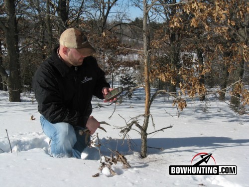
During my scouting trips I carry a GPS (global positioning system) with me. I also carry topographical and aerial maps (I will cover these later). While I’m walking my property I section it off in a grid. By breaking it down and looking at one particular area at a time so I don’t miss any important sign. I mark every bed, rub, scrape and follow every trail I can find in that given section of the grid. If you don’t own a GPS you can make notes and approximate locations on your maps. I also plot on my GPS trail camera and tree stand locations, as well as carry a note pad to make any special notes about what I may have discovered.
Once I have the property thoroughly scouted and plotted, I head back to the comforts at home. Once back at home I use mapping software to organize all my data that I plotted. The particular software that I use is Topo USA by Delrome. However you can use any mapping software that you are familiar with and that you are able to transfer the data from your GPS to the actual map. (You can get these programs either at sporting goods stores or via internet.) I mark all my deer beds with one color, rubs another, and scrapes another. I also plot out all the deer trails that I followed with my GPS and transfer them to my computer. I like to keep the deer sign on one map and my hunting stand locations and game camera locations on another map. Again this is the high tech version, if you don’t have a GPS or mapping software you can mark this information down on maps that you may have, or even draw your own maps.
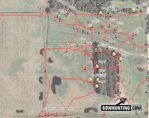
Computer mapping software allows an easy to see map of your property showing high deer travel route
By compiling all this data into an easy to read map, deer travel routes, bedding areas, and feeding areas will literally stand out at you. When hunting farm country, I like to use aerial photos for my mapping back ground, because it shows willow patches, marsh grass, timber, and fields much better. When mapping large tracts of public land such as the big woods of northern Wisconsin, I like to use topographical map as my back ground because it allows me to see ridge lines, benches, saddles, and other terrain features. If you have time on your hands you can log the data by using both aerial and topographical. Depending on your type of mapping software you can link pictures to particular waypoints that you marked by your GPS. This is particularly handy for organizing all your photos taken from different game cameras on the property and the locations that they were taken from. All these features of aerial photos, topographical maps, and compatibility with your GPS is dependent on your software, so be sure that you research a program before you buy it to make sure it will do what you need for your property.
Since we are on the topic of maps, don’t just look into your own property, study possible bedding, feeding, and watering locations on adjacent properties. Most people don’t own enough property to hold deer all year long without deer crossing the property line. So knowing what is on your neighbor’s property is just as important. (Please don’t trespass to gain this information.) By finding this information may just be the last piece of the puzzle needed to complete your property picture.
Game cameras are also very helpful tools to utilize to complete your whitetail portfolio. I don’t use game cameras as much to pattern deer, as I do to perform deer counts and what caliber of bucks that are on the property. I like to also observe what times of day are they traveling through that particular area. I label each camera as 1, 2, 3 etc., and plot their locations on my map that contains cameras and stand locations.
I also use my mapping software to plot out future food plot and tree planting locations. By doing this, allows you to better understand and explain wildlife management plans with land owners and friends that would help you with the establishment of these plans.
Now that we have are hunting property plotted out its time to compile all this information into an easy to understand portfolio of your property. I print out all the maps that I compiled along with field notes and observations that I noted during the hunting season. I also plot out wind directions on my property. To do this, I walk around my property with wind checkers and make notes of how scent currents travel down particular draws, ridges, and bottoms for a given wind direction. For example you may have a west wind, however in a particular draw the wind may swirl causing your scent to blow to the north. (Again you can be as simple or as in-depth with your maps as you would like). Once I have all these maps printed off I compile them into a binder and label the binder for that year. This gives you a permanent record of your hunting property to look at and study through the years, and also it allows you to see the progress of your wildlife management over the years.
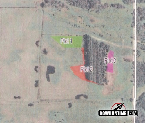
Easy to read colored plots showing locations for this spring food plot location based on scouting observations
By organizing all the data that you have learned from scouting trips on your hunting property allows organized and permanent records of deer habits and travel routes on your property. If you are like me I often forget what I ate for breakfast and I’m the type of person that I learn best by being able to see what is going on with the property that I am hunting. By establishing a portfolio of your property, potential stand locations will stand out like a beacon. The key to consistent success is spending your hunting season in high percentage stands. You can hunt all year in a low percentage stand and not fill your tag. After all, time is precious now days with our busy lives and by mapping out your hunting properties will allow you to narrow down stand locations, putting you in stands that yield a higher percent of success, giving you more bang for your buck.