LAST UPDATED: May 8th, 2015
Spring is the time of year to get out and scout for new hot spots: look over maps, talk to farmers, landowners, DNR biologists, anyone who can give you information or access into some great hunting land. We have all been there: driving around checking out fields, watching some nice looking deer grazing on the fresh greens, or longbeards struttin’ on the backside of an old cut cornfield. Whose land is it? I wonder if I could hunt it? How much land is available? Is it public, private, Forest Crop Land (FCL- possible huntable land?) Who owns it and where are the boundaries? How do you go about getting these questions answered? Simple: plat books. They have been around for years and have been getting more and more user-friendly as the time passes. I have been using plat books for over 20 years, and they have gotten me into some very nice hunting land. You would be surprised at how many people will allow you to hunt if you just ask. As hunters we need to represent the sport in the best ways possible, by asking permission, offering help on the property or being willing to pay a lease fee, are some great ways to keep up a positive image with landowners. If you are denied, so be it. Politely say thanks and move on to the next possibility.
As far as my home state of Wisconsin, our plat books are divided into the 72 counties. Each county is then divided into separate townships. As you can see in the picture, a township is a six mile by six mile square piece of land. The squaring off of the land allows these imaginary lines to be our lines of longitude and latitude to help define a specific location. Out of the 36 sections in each township, they are divided into one mile by one mile parcels which make up 640 acres in size. The sections are then quartered into four 160 acre quadrants. Thus the land can be broken down even further. The confusion begins in trying to name the location of the section by using the description technique found in the front of every plat book. I have shown a picture of how this can be done, or you can just follow the directions; starting backwards and working your way from specific description out to the section number tends to be the easiest.
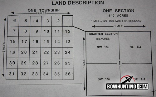
Here is a picture of how townships are divide into 36 sections each 1 mile by 1 mile.
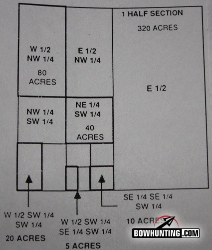
The 1 mile by 1 mile section is now divided into 4 quadrants and broken down even further if needed
A real advantage of the newer plat book is the topographical map it includes as well as the ownership map on the opposite page. This allows you to look over the land from above to find rivers, funnels, hidden fields, boundary lines etc.
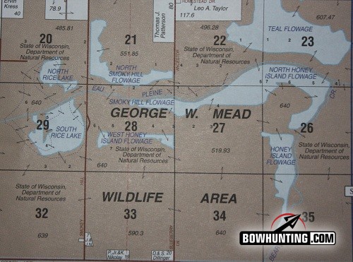
This is a copy of a section that is open to public hunting in Marathon county.
Most Midwestern states have plat books for their counties. Here is a list of just a few other states that have RMP (Rockford Map Publisher) plat books: Alabama, Illinois, Indiana, Iowa, Michigan, Minnesota, Missouri, Ohio, Pennsylvania, and of course Wisconsin. These little books can be a huge help in finding some great hot spots. They also make great gifts.